MethaneAIR will inform and augment orbital data collection by MethaneSAT, which is scheduled to launch in early 2024.
Like MethaneSAT, imaging spectrometers aboard MethaneAIR will measure methane in the atmosphere with unparalleled sensitivity, accurately tracking changes in atmospheric concentrations as small as three parts per billion.
These highly precise instruments will see emissions that others can’t at a regional scale, making it possible for the first time to measure total methane emissions over wide areas – including both large sources and countless smaller ones that are effectively invisible today.
Where MethaneAIR can cover ten target areas measuring 10,000 square kilometers each month across North America, MethaneSAT will collect data from 30 targets a day worldwide, each measuring 40,000 square kilometers.
Data from MethaneAIR will start to become available later this summer after a rigorous quality control process. It will appear on a new MethaneSAT data platform in the fall. Like MethaneSAT, MethaneAIR will also measure emissions from agriculture, landfills, and other sources.
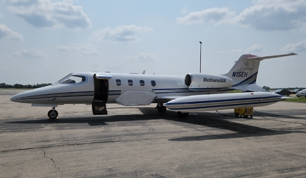
MethaneAIR was developed jointly by MethaneSAT, EDF, Harvard University and the Smithsonian Astrophysical Observatory. The leased aircraft was adapted and operated by iO Aerospace.
Retired from a private operator, the modified Lear 35 is the first jet aircraft tasked to measure methane full-time. The refit includes extended fuel tanks and special aft fins for improved stability.
It will carry two pilots and a technician, with space for one additional crew member. Operating at about 40,000 feet, above most commercial traffic, flights will last five- to six hours.
MethaneAIR and MethaneSAT are designed to help both industry and regulators achieve faster, more effective reductions in emissions of this critical greenhouse pollutant. Aircraft and satellite data will be available at no cost, enabling stakeholders to see and compare the results.
Media inquiries? Contact jcoifman@methanesat.org